


Main content:
The potential of wind energy resources is the key to the utilization of wind energy.
1. The influence of atmospheric circulation on the distribution of wind energy resources
Due to the influence of typhoons, The influence of atmospheric circulation on the distribution of wind energy resources is very large, the southeast coast, the East China Sea and the islands of the South China Sea have a maximum annual average wind speed of more than 5m/s. Dachen Island Taishan can reach more than 8m/s, and the wind energy is also the largest. The effective wind energy resources density along the coast of the Southeast China Sea is ≥200W/m2, its isoline is parallel to the coastline, and the percentage of effective wind energy resources occurrence time can reach 80% to 90%. The cumulative number of hours of wind with wind speed ≥3m/s is 7000~8000h throughout the year; the wind with wind speed ≥6m/s has about 4000h. The effective wind energy resources density on the island is 200~500W/m2. Wind energy resources can be used intensively. Taishan, Dongshan, Pingtan, Sansha in Fujian, Penghu Bay in Taiwan, Nanmo Mountain, Dachen Island, Shengsi Island in Zhejiang, etc., the effective wind energy resources density is about 500W/m2, and the wind speed is ≥3m/s. For 800h, in other words, there can be an average of more than 21h of wind speed ≥3m/s per day. However, some large islands, such as Taiwan and Hainan, have unique wind energy distribution characteristics. Taiwan's wind energy is large at the north and south ends and small in the middle; the western part of Hainan is larger than the eastern part.
In Inner Mongolia and northern Gansu, the high altitude is under the control of the westerly belt all year round. In the winter half of the year, the ground is on the southeastern edge of the Mongolian Plateau, and the cold air moves southward. Therefore, wind speeds above level 5 to 6 always appear at the turn of spring and summer and summer and autumn. Cyclone activity is frequent in the region, and wind speeds are high as each cyclone passes over. The annual average wind speed in this area is above 4m/s, the highest is 6m/s, the effective wind energy resources density is 200~300W/m, the cumulative number of hours of wind with wind speed ≥3m/s is more than 5000h, and the wind speed is ≥6m/ The wind of s is above 2000h. Its law is decreasing from north to south. Its distribution range is large, and in terms of area, it is the largest area where wind energy is connected together in China.
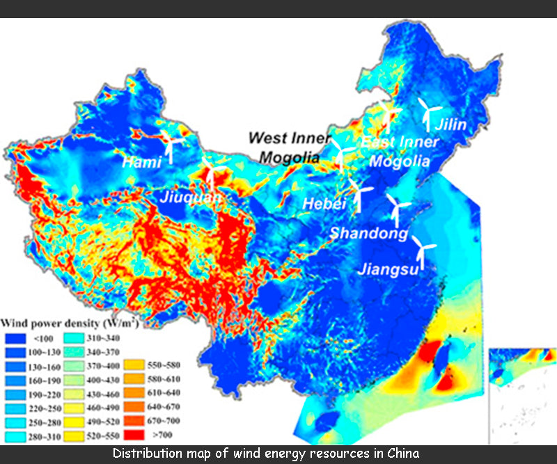
Yunnan, Guizhou, Sichuan, southern Gansu, Shaanxi, western Henan, western Hubei and western Hunan have less wind energy. Due to the influence of the Tibetan Plateau, these areas are in the dead water area of the westerly belt in the winter half year, and the cold air moving south along the East Asian trough rarely affects here. The weather system from the sea in the summer half year is also difficult to get here, so the wind speed is relatively weak, the annual average wind speed is about 2.0m/s or more, the effective wind energy resources density is below 500W/m, and the effective wind energy resources appears only about 20% of the time. The cumulative number of hours of wind with wind speed ≥3m/s is less than 2000h throughout the year, and the wind speed with wind speed ≥6m/s is less than 150h. It is the smallest in the Sichuan Basin and Xishuangbanna, and the annual average wind speed is less than 1m/s. The frequency of static winds is above 60% throughout the year, such as 67% in Mianyang, 60% in Bazhong, 67% in Aba, 75% in Enshi, 63% in Dege, 72% in Gengma Mengding, and 79% in Jinghao , the effective wind energy resources density is only about 30W/m2. The cumulative number of hours of wind with wind speed ≥3m/s is only more than 3000h throughout the year, and the wind with wind speed ≥6m/s is only more than 20 hours. In other words, there is an average of 10min wind speed ≥6m/s every 18 days or more. wind, wind energy resources are of no use value. The figure below shows the distribution of wind energy resources in China.
2. The influence of land, sea and water on the distribution of wind energy resources
China's coastal wind energy is larger than inland, and the lakes are larger than the surrounding lakeshore. This is due to the fact that the friction of the air flowing over the surface of the sea or lake is smaller and the wind speed is larger. From the coast to the inland or from the lake to the lakeshore, the kinetic energy is quickly consumed, and the wind speed decreases sharply. Therefore, the effective wind energy density utilization rate is small, and the isolines of the cumulative hours of wind with wind speed ≥ 3m/s and wind speed ≥ 6m/s are not only parallel to the coastline and lake shoreline, but also have great differences in value. The coast of Fujian is an area with abundant distribution of wind energy resources in China, and 50km away from this area, wind energy becomes a poor area. The difference between Rongcheng and Wendeng in Shandong is less than 40km. The effective wind energy resources density of Rongcheng is 240W/m2, while that of Wendeng is 141W/m2, a difference of 59%. The terrain on the coast when a typhoon makes landfall affects the wind speed, which can be divided into several aspects such as mountains, altitude and general terrain.
3. The influence of terrain on the distribution of wind energy resources
3.1 The impact of mountains on wind energy resources
When the airflow encounters the influence of terrain obstruction during operation, it will not only change the wind speed under the general situation, but also change the direction. The characteristics of its change are closely related to the shape of the terrain. Generally, the terrain with a large range has a barrier effect on the airflow, so that the airflow can move around. Therefore, most of the wind energy density lines and available hours curves in the Tianshan, Qilian, Qinling, Daxing'anling, Yinshan, Taihang, Nanling and Wuyi Mountains are parallel to these mountains. Particularly obvious are several northeast-southwest mountain ranges on the southeast coast, such as Wuyi Mountain, Daiyun Mountain, Yingfeng Mountain, and Kuocang Mountain. For all southeastern coastal mountains, the windward side of the mountain is rich in wind energy, the wind energy resources density is 200W/m2, and the number of hours when the wind speed is ≥3m/s is about 7000~8000h. In the mountainous area and its leeward side, the wind energy density is below 50W/m2, and the number of hours when the wind speed is ≥3m/s is about 1000~2000h, and the wind energy resources cannot be used. The Sichuan Basin and the Tarim Basin are blocked by the Tianshan Mountains and the Qinling Mountains as the unutilizable areas for wind energy resources. The Zhilu Zangbo River Valley is also due to the barrier effect of the Himalayas and the Gangdise Mountains, so the wind energy is small and not worth utilizing.
3.2 The influence of altitude on wind energy resources
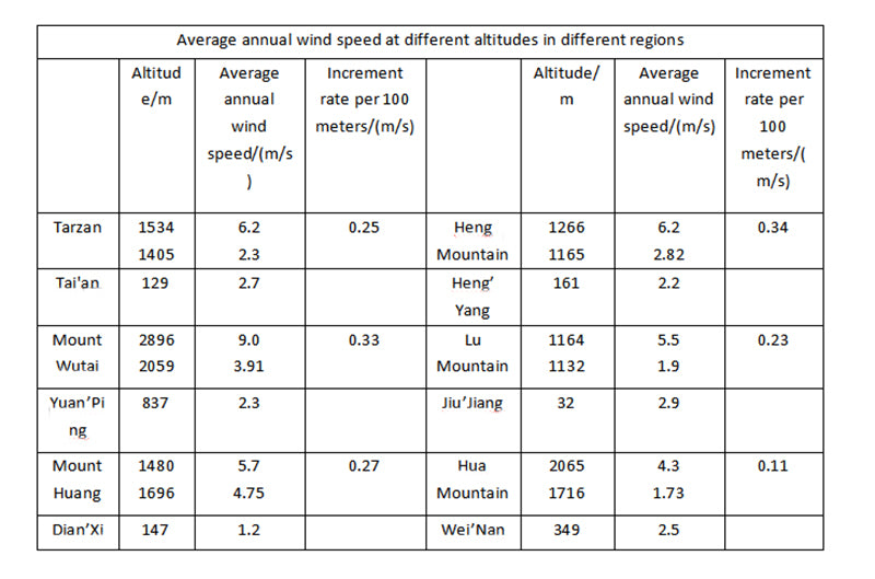
Mountain wind speeds increase with altitude because ground friction consumes energy from moving airflow. The figure below shows the comparison of the average annual wind speed between the mountains and the foothills. For every 100m rise, the wind speed increases by about 0.11~0.34m/s.
In fact, in complex mountains, it is difficult to distinguish the influence of topography and altitude, and the two are often intertwined. For example, the average wind speeds observed at the same time by the Beijing and Badaling wind power test stations are 2.8m/s and 5.8m/s, respectively, with a difference of 3.0m/s. The latter is windy, firstly because it is located in a north-south lowland in the Yanshan Mountains, and secondly because it is more than 500 meters above Beijing.
The Qinghai-Tibet Plateau is above 4000m above sea level, so the wind speed here is higher than the surrounding area, but its effective wind energy resources density is relatively small, around 150W/m2. This is due to the high altitude of the Qinghai-Tibet Plateau and the low air density, so the wind energy is small. For example, the air density at 4000m is roughly 67% of the ground. That is to say, the same wind speed of 8m/s is 313.6W/m2 when the altitude is below 500m on the flat ground, and only 209.9W/m2 at 4000m. The graph below shows the average annual wind speed at different altitudes in different regions.
3.3 The impact of small and medium terrain on wind energy resources
The wind speed is small in the sheltered terrain, and the wind speed is increased in the narrow tube terrain. Areas with obvious narrow tube effects, such as Alashankou and Dabancheng in Xinjiang, Anxi in Gansu, Xiaguan in Yunnan, etc., have significantly increased wind speeds in these places. Even in river valleys on the plains, such as the Songhua River, Fen River, Yellow River and Yangtze River, the wind energy is larger than the surrounding areas.
The strait is also a narrow tube terrain. When the wind direction is consistent with the prevailing wind direction, the wind speed is relatively large. For example, in the Penghu Islands in the Taiwan Strait, the annual average wind speed is 6.5m/s, Matsu is 5.9m/s, Pingtan is 8.7m/s, South Australia is 8m/s, and Long Island in the Bohai Strait has an average annual wind speed of 5.9m/s.
The impact of local winds on wind energy resources cannot be underestimated. In front of a small hill, the airflow is blocked and forced to lift, so at the top of the mountain, the streamline is dense and the wind speed is strengthened. On the leeward side of the mountain, the wind speed decreases due to the radiation of streamlines. Sometimes the airflow passes through an obstacle, such as a hill, and its impact is 5~10km below. Some low-level winds are created by changes in ground roughness.
Read more: Current Situation and Development Direction of Wind Power Generation Technology