
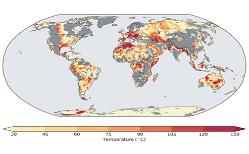

Geothermal energy is concentrated around the edges of the Earth's tectonic plates, which are also prone to volcanoes and earthquakes. It is estimated that the thermal energy transferred from the interior of the earth to the ground is equivalent to 100 PW·h each year. However, the distribution of geothermal energy is relatively scattered and difficult to develop.
Under certain geological conditions, the "geothermal system" and the "geothermal field" with exploration and development value have its occurrence, development and decline. As the concept of geothermal resource, it also has the same quantity and grade as other mineral resources. Globally, the distribution of geothermal resources is uneven. The geothermal anomalous areas with obvious geothermal gradients with a depth of more than 30°C per kilometer are mainly distributed in plate growth and cracking—ocean spreading ridges and plate collisions, decay—subtraction zones. The world's geothermal resources are mainly distributed in the following five geothermal areas:
① The Pacific Rim geotropics. The collision boundary between the world's largest Pacific plate and the American, Eurasian and Indian plates, namely from Alaska and California in the United States to Mexico and Chile, from New Zealand, Indonesia, the Philippines to the coast of China and Japan. Many geothermal fields in the world are located in this geothermal field, such as the Gaithers geothermal field in the United States, Prieto in Mexico, Huailakai in New Zealand, Manger in Taiwan, and Matsukawa and Dayue in Japan.
② Mediterranean, Himalayan geotropics. The collision boundary between the Eurasian plate and the African and Indian plates, from Italy to Yunnan and Tibet in China. For example, the Ladrello geothermal field in Italy, the Yangbajing in Tibet, and the Tengchong geothermal field in Yunnan belong to this geotropical zone.
③ Mid-Atlantic Ridge geotropics. Cracked parts of the Atlantic plate, including some geothermal fields in Iceland and the Azores.
④The Red Sea, the Gulf of Aden, the Great Rift Valley geotropics. Including geothermal fields in Kenya, Uganda, Zaire, Ethiopia, Djibouti and other countries.
⑤Other geothermal areas. In addition to the geothermal zone formed by the plate boundary, there are also high heat flow areas within the plate near the boundary under certain geological conditions, which can contain some medium and low temperature geothermal heat. ~2.0 heat flow units. Such as some geothermal fields in Central Asia and Eastern Europe, and geothermal fields in Jiaodong, Liaodong Peninsula and North China Plain in China.

Estimated geothermal power generation
China is a country rich in geothermal resources. The total geothermal resources account for about 7.9% of the world's total, and the recoverable reserves are equivalent to 462.65 billion tons of standard coal. Geothermal resources in China can be divided into three types according to their properties:
①High temperature convective geothermal resources;
②Medium temperature and low temperature convective geothermal resources;
③Medium and low temperature conduction geothermal resources. The above three types of geothermal resources are distributed in different regions of China and are closely related to the geological-tectonic background of the region.
High-temperature convection-type geothermal resources are mainly distributed in southern Tibet, western Yunnan, western Sichuan and Taiwan Province. The Pacific Rim geothermal zone passes through Taiwan Province of China, and there are more than 90 high-temperature hot springs; the Mediterranean Himalayan geothermal zone passes through southern Tibet and Yunnan and western Sichuan. . The high-temperature hot fields in Tibet are mainly concentrated in the Yangbajing rift zone. Among them, there are about 08 high-temperature hot fields in the western, eastern and central parts of southern Tibet, which constitute the most abundant high-temperature hot fields in China. Yunnan is the province with the most hot springs found in the country. There are about 20 high-temperature hot fields mainly distributed in Tengchong-Ruili area west of Nujiang River; 8 high-temperature geothermal areas are distributed in western Sichuan, which is part of the high-temperature geothermal zone of Tibet and Yunnan.
China is mainly dominated by medium and low temperature geothermal resources, and the medium and low temperature geothermal resources are widely distributed almost all over the country. Medium-temperature and low-temperature convective geothermal resources are mainly distributed in coastal zones such as Guangdong, Fujian, Hainan and other provinces; medium- and low-temperature conduction geothermal resources are distributed in Mesozoic and Cenozoic large and medium-sized sedimentary basins such as North China, Songliao, Sichuan, Ordos, etc. Such resources are often located in the same basin as oil and gas or other mineral resources such as coal. Medium and low temperature geothermal resources, its main thermal reservoir is Tertiary sandstone glutenite with a thickness of several hundred meters to several thousand meters, and the temperature is about 40~80 °C. At present, there are more than 3,000 geothermal hot springs in China, of which the temperature is higher than 25 °C. of about 2200. Judging from the exposure of hot springs, there are mainly four areas of intensive hydrothermal activity in China: southern Tibet, western Sichuan and western Yunnan; intensive hydrothermal activity in Taiwan; intensive hydrothermal activity in the southeastern coastal areas; and Jiaodong Liaodong Peninsula. Intensive zone of hydrothermal activity.
Geologically, geothermal resources in China are mainly distributed in tectonic active belts and large-scale accumulation basins, and the main types are sedimentary basins and uplift-mountain types. In a unit time, the heat energy emitted in a unit area of the surface can be measured. The measurement results show that the distribution of heat flow in the earth is not uniform. The reason is related to the geological structure and magmatic activity. Accordingly, scientists have divided China's geothermal system into two categories and five subtypes.
The first category is the heat flow in the tectonic uplift area, which refers to the orogenic uplift belt where the crustal uplift area and the geological block collide. It includes 3 types, ①volcanic type. There is volcanic activity on the edge of the uplift area, which brings strong geothermal flow. ② Non-volcanic, geothermal flow generated at the edge of the collision body. ③Deep circulation type, hot spring thermal fluid formed by fault zones between geological blocks.
The second category is heat conduction in tectonic subsidence areas, mainly referring to the areas where basins are formed due to subsidence of the crust and receive redeposition. It includes two types: (1) rifted basin type, in which there are deep faults on the edge of the basin, and there is a low-temperature heat transfer system of carbonate rocks;

Photo by Logan Fisher on Unsplash
Natural hot spring
Geothermal resources in the structural uplift area are characterized by hydrothermal activity. The hydrothermal activity in China is displayed in the form of hot springs, including single springs and group springs. "Hot spring" refers to the spring water gushing out of the ground. The temperature higher than the local average temperature is called "hot spring", and there are also boiling springs, boiling fountains, geysers, jet springs, etc.
The hydrothermal activity is related to the geological structure, and the structural uplift area is formed by the combination of geological blocks. China's Tibet, Yunnan, Sichuan, Fujian, Taiwan and other places are all areas with high temperature and water heat. High-temperature hydrothermal areas are related to Cenozoic volcanoes, such as Tengchong in Yunnan, Datun in Taiwan, and Guishan Island in Keelung. Most of the low hot springs are related to carbonate rocks and are widely distributed. They are found in East China, North China, Northeast China, Northwest China, and Central South China. They appear in the form of karst (karst caves) low hot springs. The hydrothermal activity intensive zone, controlled by the geological structure, can form the intensive hydrothermal activity area, such as Tibet, Sichuan, Yunnan, Taiwan, Southeast, Liaodong and coastal areas.
Concealed geothermal resources in tectonic subsidence areas are often not displayed strongly on the surface, and usually appear in the form of concealment. A large number of geological surveys have shown that large-scale subsidence basins are conducive to the formation and preservation of hydrothermal resources, because the basins are large and the sediments are thick, which is conducive to water circulation, sufficient heat absorption and accumulation. In addition, due to the low thermal background value of the basin, some basins can only contain low-temperature hot water. This is the case in some basins in the east, west, north and central parts of China.
The development of hot water reservoirs is related to sedimentary formations. Sedimentary formations refer to the synthesis of sedimentary rock composition and environment, such as freshwater sedimentary rocks, saltwater lake sedimentary rocks, volcanic rocks, volcanic sedimentary rocks, and carbonate rocks. They have different degrees of development of hot water.
The hot spring resources in the uplift area are widely distributed and rich in resources in China. They have been developed in many areas and are mainly used for power generation, agricultural breeding, medical treatment, etc., with good prospects. The development of hydrothermal resources in the subsidence basins is very unbalanced. The large basins in East China, North Jiangsu and North China have good prospects and large reserves of hydrothermal resources, but the northwest is poor and there are many salty hot springs. Salt brine from Sichuan Basin can be used as chemical raw material. In geothermal development, the development of hot water in the basin can cause crustal subsidence, and the development of salt water can cause surface salt pollution, all of which need to be further studied.