


main content:
1. Distribution of wind energy resources in China

The distribution of wind energy resources in China has a very close relationship with the weather and climate background. The regions with rich and abundant wind energy resources in China are mainly distributed in two large belts.
(1) The rich zone of the Three Norths (Northeast, North China, Northwest)
The power density of this wind energy rich belt is above 200 ~ 300 watts/m², and some can reach above 500 watts/m², such as Alashankou, Dabancheng, Huitengxile, Xilinhot’s Huiteng beam, etc. The available hours are 5000 Hours or more, and some up to 7000 hours or more. The formation of this wind-rich belt is mainly due to the geographical location of the Three Norths in the middle and high latitudes.

Every winter (December-February) the entire Asian continent is completely controlled by the Mongolian high pressure. Its center is located in the northwest of the Mongolian People's Republic. From the high pressure, a small stream of cold air continues to flow southward into China. At the same time, mobile high pressures (anticyclones) invade China from time to time southward. Due to the large area of Eurasia and the low temperature in the northern region, it is the region with the most frequent cold high pressure activity in the northern hemisphere. China is located on the east coast of Eurasia, which is the only way for cold high pressure to travel south. The Sanbei area is the frontier of cold air intrusion into China. The cold high-pressure front is generally called cold front. When the cold front passes, strong winds around 200km behind the cold front can cause a level 6-10 (10.8-24.4m/s). Gale. For the utilization of wind energy resources, it is a high-quality gale that can be effectively used at one time.
From the Three Norths area to the south, as the cold air travels long distances from the source, reaching the middle and lower reaches of the Yellow River in China and then to the middle and lower reaches of the Yangtze River, the surface temperature has risen, causing the original cold and dry air flow to gradually change to a cooler and humid air flow. (Called degeneration), that is, the cold air gradually warms up, and the air pressure difference becomes smaller at this time, so the wind speed gradually decreases from north to south.
Eastern China is located on the east and southeast sides of the Mongolian High, so the prevailing wind direction is northerly wind. The actual northerly angle differs depending on its position relative to the center of the Mongolian High. Northwest winds prevail in the Three Norths, and the prevailing winds are between the north and the northeast in the vast area south of the lower reaches of the Yellow River in the Qinling Mountains.
Spring (March to May) is the transitional season from winter to summer. Due to the continuous increase in ground temperature, the intensity of the Mongolian high in the middle and high latitudes has been significantly weakened since April, while the Indian low (continental low) ) And the trough of low pressure extending northeast, has controlled the southern China region. At the same time, the Pacific subtropical high has gradually intruded northward from the Philippines to the coastal area of South China. The strength and weakness of these high and low pressure systems It plays an important role in China's wind energy resources.
In the spring, these types of air currents exchange frequently in China. Spring is the season with the most cyclone activity in China, especially the frequent cyclone activities in northeast China and Inner Mongolia, causing strong winds and sandstorms in Inner Mongolia and Northeast China. The same Jiangnan cyclone activity is also more frequent, but the result is the spring rain and the rainy season in southern China. This is also one of the main reasons why the wind resources in the Three Norths are more abundant than in the South. The wind direction across the country is not as stable and less variable as the winter monsoon, but the northerly wind is still dominant, but the southerly component of the wind has increased significantly.
In summer (June-August), the distribution of surface pressure in East Asia is completely opposite to that in winter. At this time, it is not clear that the Mongolian high pressure in the middle and high latitudes is retreating northward. On the contrary, the Indian low pressure continues to develop and control the Asian continent, which is the heaviest season of the year. The Pacific subtropical high also extends northward and westward to the mainland. It can be said that the summer weather and climate changes in East Asia are basically restricted by the strength and interaction of these two circulation systems.
As the Pacific subtropical high stretches from the west to the north and jumps from the north, eastern China can be affected by it. The west of this high pressure brings abundant precipitation to the southeast and southwest airflow. However, due to the small pressure difference between the high and low pressures, the wind speed Not big, summer is the season with the lowest wind speed in the whole year.
In summer, the mainland is hot and low pressure, and the sea is high pressure. The isobars between high and low pressures are distributed in the north-south direction in eastern China, so the southerly wind prevails in the summer monsoon.
Autumn (September-November) is the transitional season from summer to winter. At this time, the Indian Low and the Pacific High began to decline significantly, while the Mongolian High in the middle and high latitudes began to become active again. Because the winter monsoon comes quickly and remains stable, it is not like the back and forth form of the winter monsoon that the mid-summer monsoon in spring represents the winter monsoon. At this time, the southeast coast of China has gradually been affected by the edge of the Mongolian high pressure. The situation of the winter monsoon has been established in the autumn of the Three Norths. There are mostly stable northerly winds everywhere, and the wind speed has begun to increase.
(2) Abundant belts along the coast and its islands
In this wind energy-rich zone, the annual effective wind power density is above 200 W/m², and the wind power density line is parallel to the coastline, and the wind power density of coastal islands is above 500 W/m², such as Taishan, Pingtan, Dongshan, Nanlu, and Dashan. Chen, Shengsi, Nanao, Matsu, Magong, Dongsha, etc., the available hours are about 7000-8000 hours. This area, especially the southeast coast, is continuous with hills from the coast to the inland, so the wind-rich areas are only within 50km of the coast. Not only is it not an area rich in wind energy, but also the smallest wind energy area in the country. The wind energy power density is only about 50 watts/m², which is basically an area where wind energy cannot be used.

Coastal wind energy-rich belts have basically the same weather and climate background as the Three Norths. The difference is that the ocean and the continent are composed of two completely different substances, and there are obvious differences in the radiation and thermodynamic processes of the two. The energy exchange between the atmosphere and the ocean is very different. The ocean temperature changes slowly and has obvious thermal inertia. The continental temperature changes quickly and has obvious heat sensitivity. In winter, the ocean is warmer than the continent, and the summer is cooler than the continent. The effect of this kind of sea-land temperature difference is that whenever cold air reaches the sea in winter The hourly wind speed increases, coupled with the smooth surface of the ocean and low friction, the general wind speed is 2-4m/s higher than that of the mainland.
The southeast coast is also affected by the Taiwan Strait. When the cold air arrives southward, the wind speed increases due to the narrow tube effect. This is the region with the best wind energy resources in China. Tropical cyclones can be affected every summer and autumn along the coast. When the wind speed of tropical cyclones reaches level 8 (17.2m/s) or more, it is called a typhoon. A typhoon is a circular cyclone with a diameter of about 1000km. The central pressure is extremely low. The eye of the typhoon is within the range of 0-30km from the center of the typhoon. The weather on the outer wall of the typhoon eye is the worst, and the maximum damage wind speed appears in this range. Therefore, as long as it is not directly landed in the front of the typhoon, the wind speed is generally less than 10 (26m/s), and its impact is 800~1000km on average. Diameter range. When a typhoon makes landfall, a strong wind process can occur along the coast of China, and the wind speed is basically within the cut-out wind speed range of the wind turbine, which is a good opportunity for full power generation.
There are 11 landfall typhoons in China each year, while Guangdong has a maximum of 3.5 landfall typhoons each year, followed by Hainan 2.1 times, Taiwan 1.9 times, Fujian 1.6 times, and Guangxi, Zhejiang, Shanghai, Jiangsu, Shandong, Tianjin, and Liaoning total only 1.7 times. It can be seen that the area affected by the typhoon decreases from south to north, and the wind energy resources are also large in the south and small in the north. After the typhoon made landfall, the central air pressure rose extremely fast, and the overlapping mountains from the northeast to southwest along the southeast coast resulted in strong winds only within a few tens of kilometers from the coast. The power density of wind energy has dropped sharply from 300w/m² to below 100w/m².
In summary, the cold air in winter and spring and the typhoon in summer and autumn can affect the coast and its islands. Relative to the inland, there is a rich belt of wind energy in China. Due to the narrow tube effect of the Taiwan Strait, the southeast coast and its islands are the best areas for wind energy in China. China has a coastline of more than 18,000 kilometers and more than 6,000 islands. This is an area with great prospects for the development and utilization of wind energy.
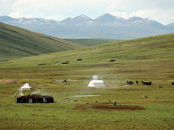
(3) Inland areas rich in wind energy

Outside the two wind-rich belts of the two major belts, there are inland wind-rich areas. The wind power density in this wind-rich area is generally below 100w/m², and the available hours are below 3000 hours. However, in some areas, due to the influence of lakes and special topography, wind energy is also richer. For example, the wind energy near Duyang Lake is greater than that in the surrounding areas, and Hengshan Mountain in Hunan, Huangshan Mountain in Anhui, and Taihua Mountain in Yunnan also have more wind energy than flat ground. However, these are limited to a small area, not as large as the two major belts, especially the three north areas. The Qinghai-Tibet Plateau is above 4000m above sea level. The wind speed here is relatively high, but the air density is low. For example, the air density at 4000m is roughly 67% of the ground, that is to say, the wind speed is also 8m/s, and the wind power density on the plain is 313.6 w/m², and only 209.9w/m² at 4000m, and the annual average wind speed here is 3~5m/s, so wind energy is still in the general area.
2. China's wind energy resource reserves

China is located in the eastern part of the Asian continent, close to the Pacific Ocean. The monsoon is strong, and there are many mountain systems in the interior. The complex terrain and the Qinghai-Tibet Plateau is a land mass standing in the atmosphere. This has changed the pressure distribution and atmospheric circulation caused by the influence of land and sea, and increased the Chinese monsoon. Complexity. The winter monsoon comes from the inland areas of middle and high latitudes such as Siberia and Mongolia, where the air is very cold and dry, and the cold air accumulates to a certain extent. Under the guidance of favorable high-altitude circulation, it will break out to the south, commonly known as the cold wave. Under the control and influence of the air, a cold and dry northwest wind formed and struck the provinces (municipalities and autonomous regions directly under the Central Government) in northern China. Strong cold air that drastically cools down many times every winter goes south, mainly affecting Northwest China, Northeast China, and North China. It does not disappear until the turn of the spring and summer the following year.
The summer monsoon is the southeast wind from the Pacific Ocean, the southwest wind from the Indian Ocean and the South China Sea. The southeast monsoon affects the eastern half of China, and the southwest monsoon affects the southwestern provinces and the southern coast, but the wind speed is far lower than the southeast monsoon. Tropical storms are air vortices formed in the western Pacific Ocean and the tropical oceans of the South China Sea. They are ocean storms with extremely destructive power. They frequently invade China in summer and autumn and land on the coast of the South China Sea and the southeast coast. Tropical storms can also travel north of Shanghai. Log in, but very few times.
The Qinghai-Tibet Plateau stands tall and the terrain is high and wide. In winter, southerly wind prevails in the southeast, and northeast wind is mostly in the northeast. In other areas, it is generally westerly wind. In summer, it is bounded by Tanggula Mountain, with southeast wind prevailing in the south, and northeast from north to east. wind.
China has a vast territory, with a total land area of more than 20,000 kilometers, and a coastline of more than 18,000 kilometers. There are more than 5,000 islands in the fringe sea and rich in wind energy resources. The annual average wind speed of China's existing wind farm sites has reached 6m/s or more. It is generally believed that the wind conditions of wind farms can be divided into three categories: when the annual average wind speed is above 6m/s, it is better; when the average wind speed is above 7m/s, it is good; when it is above 8m/s, it is very good. According to the wind speed frequency curve and the unit power curve, the annual power generation of the unit under international standard atmospheric conditions can be estimated. China is equivalent to an area above 6m/s, which is limited to a few areas across the country. As far as the inland is concerned, it only accounts for 1/100 of the total area of the country. It is mainly distributed on the southeast coast between the Yangtze River and Nan'ao Island. Its islands are China's largest wind energy resource area and an area rich in wind energy resources. Resource-rich areas include Shandong, the Liaodong Peninsula, the coast of the Yellow Sea, the South China Sea coast to the west of Nan'ao Island, Hainan Island and the South China Sea Islands, Inner Mongolia from the north of the Yinshan Mountains to the north of the Daxingan Mountains, Xinjiang Dabancheng, Alashankou, Hexi Corridor, and Songhua River Downstream, the northern part of Zhangjiakou and other areas, as well as the high mountain passes and mountain tops distributed in various places.
About 2% of the energy radiated by the sun is converted to wind energy on the earth's surface. Wind energy is part of the natural energy on the earth. The wind energy potential of China is estimated as follows:
The theoretically developable total wind energy R is 3.226 billion kw across the country. The actual developable utilization R'is estimated at 1/10 of the total, taking into account that the actual sweeping area of the wind wheel is 0.785 times the calculated airflow square area (1m The diameter of the wind wheel area is 0.52 xπ=0.785m²), so the actual developable volume is: R'=0.785R/10=253 million kw.
That is to say, the total reserves of wind energy resources in China's 10m height layer are 3.226 billion kw, of which the actual reserves of wind energy resources that can be developed and utilized are 253 million kw. The southeast coast and nearby islands are areas rich in wind energy resources. The effective wind energy density is greater than or equal to 200W/m² and the contour line is parallel to the coastline; the effective wind energy density of coastal islands is greater than 300W/m², and the annual wind speed is greater than or equal to 3m/s. The hour is about 7000-8000h, and the hour greater than or equal to 6m/s is 4000h.
Northern Xinjiang, Inner Mongolia, and northern Gansu are also regions with rich wind energy resources in China. The effective wind energy density is 200-300W/m². The annual wind speed is greater than or equal to 3m/s for more than 5000h, and the annual wind speed is greater than or equal to 6m/ The hour of s is more than 3000h.
Heilongjiang, eastern Jilin, northern Hebei and Liaodong Peninsula also have good wind energy resources. The effective wind energy density is above 200 W/m². The annual wind speed is greater than or equal to 3m/s for 5000h, and the annual wind speed is greater than or equal to The hour of 6m/s is 3000h.
The effective wind energy density in the northern part of the Qinghai-Tibet Plateau is between 150-200W/m², the annual wind speed is greater than or equal to 3m/s for 4000~-s000h, and the annual wind speed is greater than or equal to 6m/s for 3000h; but the Qinghai-Tibet Plateau The altitude is high and the air density is low, so the effective wind energy density is also low.
The mountainous areas of Yunnan, Guizhou, Sichuan, Gansu, southern Shaanxi, Henan, western Hunan, Fujian, Guangdong, Guangxi, the Tarim Basin in Xinjiang and the Yarlung Zangbo River in Tibet are areas with poor wind energy resources. The effective wind energy density is below 50W/m². The number of hours with wind speed greater than or equal to 3m/s is below 2000h, and the number of hours with wind speed greater than or equal to 6m/s in the whole year is below 150h, and the wind energy potential is very low.
China is located in the southeast of the Asian continent, on the west coast of the Pacific Ocean, and the monsoon is strong. The monsoon is the basic feature of China's climate. For example, the winter monsoon lasts for 6 months in North China and 7 months in the Northeast. The southeast monsoon spreads over the eastern half of China. According to estimates by the National Meteorological Administration, the total reserves of wind resources in the country are 1.6 billion kw per year, and the recent development is about 160 million kw. Inner Mongolia, Qinghai, Heilongjiang, Gansu and other provinces have the highest wind energy reserves in China, with an average annual wind speed of more than 3m/s. The number of days is more than 200 days.